|
|
Clan
Henebry
Association
TM
Henebry/Henneberry Families from the Irish counties of |
| Home | Site Map | Message Board | Contact Us | Clan Henebry |
Online Since March 1995 |
|
|
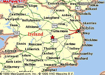
Map from: Mapquest.com The County of Laois is one of the most strategically located
counties in Ireland. Portlaoise, the county town, is located at the junction of
National Primary Route N7 and National Primary Route N8, both routes being of
major importance in the country's transportation network.
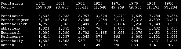
Note: The population of
County Queens (Laois) decreased by 41 percent from 1841 to 1861. The two articles below demonstrate the difficulty many find in tracing the Irish birthplace and residence of their family members. Irish Place Names and the Immigrant: Divisions By Dwight A. Radford and Kyle J. Betit Provinces Ireland has historically been divided into the provinces of Connaught, Leinster, Munster, and Ulster. There are several counties in each of these historical provinces. Most often passed down in family lore are the provinces of Connaught and Ulster. This is especially true in the cases of Scots-Irish (Ulster-Scots) who were concentrated in the historical province of Ulster and of Catholic immigrants who stated they were from Connaught. There are four provinces in Ireland, Ulster (9 counties), Connacht (5 counties), Munster (6 counties) and Leinster (12 counties) If a province of origin is known, research can concentrate on narrowing the place of origin within that province. Searching indexed tax or other records for the province may be practical for an uncommon surname but not for a common one such as Kelly or Lynch. Geographical Regions There are geographical region names in Ireland which the immigrant may have identified as a place of origin, some large and some small. For example, family legend may state an ancestor was from Connemara, the mountainous and coastal region of western Galway; the "midlands" in the County Longford area; the "lake district" in County Fermanagh; or the Dingle peninsula in County Kerry. Identifying these geographical regions may be the key to finding where the
ancestor was from. For example, if an ancestor originated in Connemara, the
Galway Family History Society West heritage centre could be contacted to check
church indexes for western Galway. This may identify in which parish in the
Connemara region the ancestor originated. Barony: Up to the end of the nineteenth century, counties were subdivided into baronies, although they were not much used for administrative purposes and thus figure little in the records relevant to genealogical research. There were about 325 baronies in the country. Counties The county name is most often preserved as a place of origin in Ireland. The island was historically comprised of thirty-two counties. Queen's County became County Leix (or Laois) and King's County became County Offaly after Ireland was divided in 1921. Derry and Londonderry are interchangeable names for the same county. Parishes There are two types of parishes involved in Irish genealogical research, the civil parish and the church (or ecclesiastical) parish. These are not the same and should not be confused. The Church of Ireland and the Roman Catholic Church had separate parish systems. Since the Church of Ireland was the Established Church, its parish boundaries were often the same as the civil parishes. There were not enough members to warrant a Church of Ireland parish church in each civil parish. One parish church could thus serve several civil parishes. Also, there could be more than one Church of Ireland parish within a civil parish. This was especially true in Northern Ireland where there were greater numbers of Church of Ireland members. The civil parish is an important boundary for land and taxation purposes. It is also the boundary used to catalog many Irish records at several repositories including the Family History Library (FHL) in Salt Lake City. With the re-emergence of the Roman Catholic church in the later eighteenth century and with full Catholic emancipation in 1829, the Catholic parish system rapidly expanded. Many new Catholic parishes were established. A civil parish may have one or more Catholic parishes within its boundaries. The Catholic and civil parish names may or may not be the same. For further discussion of this topic, see Nora M. Hickey's article "The Relationship Between Civil & Catholic Parishes" in Irish Family History. Many immigrants listed the civil parish as a place of origin. A Catholic parish may have been listed in church records or on a tombstone in a Catholic cemetery. Immigrants were asked where they were baptized when they got married. In this case, the ecclesiastical parish of baptism would be given. Maps of the civil parish boundaries of all counties have been published in Brian Mitchell's A New Genealogical Atlas of Ireland. Approximate Catholic parish boundaries in each county can be found in John Grenham's Tracing Your Irish Ancestors: The Complete Guide. Brian Mitchell's A Guide to Irish Parish Registers lists Church of Ireland parishes, Roman Catholic parishes, Presbyterian and other congregations within each civil parish. Samuel Lewis' 1837 Topographical Dictionary of Ireland indicates the congregations within each civil parish. The Ordnance Survey Memoirs compiled in the 1830s also list the congregations within each civil parish. Cities and Towns Cities and towns in Ireland must be thought of in a different light than they are, for example, in North America. In Ireland towns are not townlands, but towns or villages may be located within one or more townlands. For example, the town of Draperstown in County Londonderry (Derry) lies in the three intersecting townlands of Cahore, Moykeeran and Moyheeland. When names of these populated places are given as a place of origin, caution must be applied. Immigrants often stated they were from a certain populated place such as Athlone (a town on the border of counties Roscommon and Westmeath), when in reality they were from outside the populated town in a nearby townland. Another word of caution concerns family legends stating that an immigrant was from Cork, Dublin, or Londonderry (Derry). First, these are all the names of both cities and counties, and the distinction can become blurred in family lore. Second, these cities were ports where immigrants left Ireland. What was stated in family tradition as the family's place of origin could have actually been the place of departure, and the immigrant may be from an entirely different county. Townlands The townland is the smallest administrative unit in Ireland. A townland is not a town, nor does it have a government. A townland is a surveyed piece of ground which may not even have people living within its boundaries. Townlands usually but not always have Gaelic names. A townland in Ireland may consist of anywhere between a few acres and several thousand acres. Townlands have specific boundaries which were officially surveyed in the 1830s by the Ordnance Survey. Due to their small size townlands do not usually appear on standard road maps. However, the Ordnance Survey has published modern maps of Ireland indicating townland names. Although the concept of the townland is based in antiquity, the actual mapping and defining of them goes back to the 1600s when the English Government was mapping Ireland to portion it out to conquering soldiers and others who were investing in Irish land. From the 1600s to the Ordnance Survey of the 1830s, many changes occurred in the townlands and their boundaries. This is reflected in antique maps and estate maps. A Census of Ireland, Circa 1659, edited by Séamus Pender, lists the townland names at that time and contains a full index to place names. An example of changes in 145 years may be found in Andrew J. Morris' article "Irish Placenames," in Eirephile. Morris included two maps showing the townlands in the East Kerry estate of the Earl of Kenmare. The map dated 1720 shows several large townlands on this estate. The other map dated 1865 shows many more townlands of smaller size. Since there may be many townlands of the same name in a county, it is important to identify the correct one. Tax records, land records, and other sources can assist in documenting the ancestral family in the correct townland. It may take some research to determine what the official spelling of a particular townland really is. Townland names can be found in the 1851, 1871, and 1901 townland indexes, all of which identify the civil parish in which the townland is located. The 1851 edition was reprinted by Genealogical Publishing Company. The townlands of Ireland are being placed in a computerized database on the Internet at the IreAtlas Project web site. Townland Sub-denominations Within the official townlands there are other smaller subdivisions such as field and farm names known to the local people. There are also small communities within townlands not large enough to be towns; these communities have unique names and may only include a few houses. The townland was and is the smallest officially recognized geographical unit in rural Ireland, varying in size from a few acres to several thousand. There are more than 65,000 recorded in the 1851 Townlands Index.These sub-denominations within a townland ("Cherry Grove" in Croom civil parish, County Limerick, for example) are not listed in the 1851, 1871, and 1901 townland indexes. Sub-denominations may, however, be found in official records such as civil registration or on the Ordnance Survey maps of Ireland. For this reason, examining the "Manuscript Index to the Original 6" to the Mile Ordnance Survey Maps" may be the quickest method of determining in which townland, civil parish, and county an obscure place name is located. It is not uncommon for an immigrant to identify with one of these small parcels of ground rather than with the townland name. Irish Place Names and the Immigrant: Examples By Dwight A. Radford and Kyle J. Betit Two examples of how the indexes can be used for identifying origins come from Cherry Grove, County Limerick, and Whiskey Hill, County Tyrone. An immigrant from County Limerick stated in his American Civil War papers that he was from Cherry Grove, County Limerick. This place name could not be found in the various townland indexes. However, it was identified in the "Manuscript Index to the Original 6" to the Mile Ordnance Survey Maps" as being in the civil parish of Croom. This was confirmed through the Catholic parish registers of Croom which listed Cherry Grove as a residence for the family. The situation of Whiskey Hill was somewhat more complex. A search of the Catholic registers at the PRONI showed one entry in the records of the Catholic parish of Strabane which could be for the family. The register stated that the family was from Whiskey Hill. Upon examining the various townland indexes no Whiskey Hill could be found. In the printed Tyrone index to minor place names in the Bulletin of the Ulster Place Name Society Whiskey Hill was found to be Whisker Hill, a place in the townland of Tullywhisker.
|
|
Copyright 1990-2007:
RMK Research. All rights
reserved. You may link to this site, but NO photos or information may be
copied without prior written permission. Any infringement will be
subject to legal action. Website hosted and designed by Ronald M. Knowles,
member: Moultrie County
Historical & Genealogical Society.
Disclaimer
Site sponsored by:
SMOGCHECK.COM™ and
SmogTestOnly and
TestOnlySmogCheck
and
OrangeCountySmogCheck.Biz
and AnaheimSmog.Biz and
CostaMesaSmog.Biz and
SantaAnaSmog.Biz and
WestminsterSmogCheck.Biz
and OCSmogCheck.Biz
and Garden Grove Smog Check
and Mainstreet Smogcheck and
SmogTest.Biz and
Huntington Beach Smog Biz and
Smog Check California and
Smog Test California |